Tuesday, November 30, 2010

MapMyTri


The geospatial web is a relatively new term that represents the merging of geographical and abstract information that is currently dominating the internet (ESRI par. 1). It has had a profound impact on managing knowledge, structuring facts, and communicating with individuals in virtual communities. The concept was first introduced by Dr. Charles Herring in his 1994 paper “An Architecture of Cyberspace: Spatialization of the Internet”, which kick-started the development GIS with new technologies, concepts, and products (Anders par. 18). Today the internet holds a wide array of geospatial applications to explore, which all carry specific themes and objectives. For example, the MapMyFitness corporation which has created geospatial websites such as MapMyRun, MapMyRide, MapMyMountain, MapMyHike, and MapMyWalk, are all fitness-oriented. By using satellite images provided by Google Maps these applications allow individuals to create specific exercise routes around the world. Users also have the ability to view maps created by others, allowing information like the advantages and dangers of their courses to be seen. Overall, the most dynamic and intricate application created by this company has been MapMyTri, which allows individuals to create their own triathlon route “with just a few mouse clicks” (MapMyTri par. 2). However, even though MapMyTri does have clear benefits for avid athletic enthusiasts, it still carries fallbacks such as pop up advertisements, and poor security. It is because of the obvious strengths and weaknesses of this geospatial website that we found it to be best suited for a critical overview.

Laura Curk
Steven Allison
Ashley Gyori
Olivier Leonard
Erin Gouweleeuw
MapMyRun


The subject if this report is the geospatial application www.mapmyrun.com. This website uses mapping technology from Google Maps to provide users with a platform in which they can input personal data and receive accurate, tangible numbers to measure the effects of their exercising. From this perspective, it could be used by any level of athlete, from the weekend cyclist so the seasoned marathoner, to help set goals (in distance travelled, avg. speed and lap times) and give oneself measurable feedback, such as the number of calories burned based on one’s Body Mass Index. Say you are a fitness enthusiast travelling out of town. If the settlement you’re in has been mapped by Google, you could draw a route along the streets of the city you’re in, and MapMyRun will update the route distance as you set waypoints. Also, you have access to Google’s satellite imagery, which allows you to view the surface of the earth via aerial photographs. This way the user can be aware of the terrain they will be travelling through.

Samantha Tremmel
Clara Greig
Kayla Jefferson
Thomas Rolf
Cody Bachmann

Foursquare


Foursquare is a mobile geospatial application that can be accessed through either a web based browser or a Smartphone. This application allows one to ‘check in’ to specific places, such as restaurants, schools, stores, amusement parks, offices, and much more. By checking in you can automatically get points, tips, and interesting information regarding your location. Upon ‘checking in’ one can see what other friends are at that location, as well as a foursquare history for the location.  When a member ‘checks in’ to a site they can also provide a ‘shout’. A shout is a brief message regarding what is on your mind, it is directed to your foursquare friends. Foursquare is not only a source of geospatial information, but it is also a game in which members can collect points and receive tangible rewards for their dedication. For example if one ‘checks in’ to a place very often, they can become the ‘mayor’ of that place. A mayor can then receive ‘specials’ at their current location; this could include anything from half off drinks to a complimentary gift. Users can also collect badges; they are awarded for following a certain brand and for visiting locations. Foursquare allow members to upload photos whilst at a location. Other friends and members can then view these photos pertaining to a specific location. The purpose of this application is to link social networking with informative geographical data. This application encourages sharing information with your friends, its purpose is to connect people and provide helpful information about the places one frequents.

Matt Polley
Jamie Stewart
Royce Ellis,
Kelsey Pettit
David Paone

Gowalla


Gowalla Inc. is a geolocation application that functions as a website and mobile service. By using the Gowalla application, users are able to “check in” (see figure 1) to locations and build a passport of all the places they have been. Users can also create trips and follow trips that others have created. Through travelling to different locations and completing trips, users collect pins and build an overall profile where they can upload pictures and other information about their life. Gowalla is mainly used as a location-based social networking site to connect real people to real locations. It can be accessed through Twitter and Facebook. Gowalla’s main purpose is to act as a geospatial web application to connect friends and family. Most users of the application use it mainly for its entertainment value rather than the geospatial function. The Gowalla application is not only useful for social networking for users, but also for geospatial analysis by third-parties. Businesses can analyze the information in order to see patterns and trends among users, including locations and interests. Gowalla is applied on an individual level to create personal projects, such as trips (see figures 2 and 3), so that other users can follow their paths and activities. Larger-scale projects created by third-parties allow users to follow trips that take them to their business locations in order to market their company to a larger audience.  

(Brandon) Scott Conzelmann
Chelsea Deakin
Aishwarya Muralidhar
Rachel Schaus

Polar Bear Tracker


The WWF-Canada Polar Bear Tracker is a project created by the Canadian World Wildlife Fund that tracks polar bears through the Arctic. Radio collars are placed on the bears’ necks, and their positions are recorded and sent via satellites to researchers, who then plot the movement of the bears on Google Maps.

The Polar Bear Tracker is an important geospatial application for a number of reasons. Firstly, the tracker provides information on how the polar bears are adapting to the changes in sea ice volume. Polar bears are considered indicators of an ecosystem’s health because they are at the apex of the arctic food chain. Thus, a polar bear at risk is an indication that there is something wrong elsewhere in the ecosystem (“Polar Bear Tracker”). Secondly, the tracker provides scientists with information that can be used to improve conservation and management efforts, and also allows them to further understand the global impacts of phenomena such as climate change and habitat loss (“Polar Bear Tracker project areas”). There are several application projects associated with the data provided by the Polar Bear Tracker. For example, using the collected data, the World Wildlife Fund is gaining an understanding of where the polar bears travel, monitoring the health of the bears, and determining their average lifespan (“Tracking Polar Bears”). Organizations outside of the World Wildlife Fund are also using polar bear tracking in predictive science and strategy development regarding arctic wildlife. The Alaska Science Center is using the information concerning the adaptation of polar bears to changes in ice quality and quantity to predict how future polar bear generations will be affected by ice changes. These predictions will allow for the development of strategies to ensure the long-term survival of polar bears in an environment that is vulnerable to changes in sea ice (“Polar Bear-Sea Ice Relationships”).

Erik Paige
Lauren Knowles
Brett Mullen
Dallas Cotterell
Karli Allen

Cabspotting in San Francisco


For our geospatial web application case study we have chosen to examine a project called Cabspotting. It is a part of San Francisco Exploratorium’s Invisible Dynamics initiative. Cabspotting traces San Francisco’s taxi cabs as they travel throughout the Bay area. The collected data is used to create live and constantly changing maps of city life.

This initiative is attempting to investigate alternate views of the Bay area’s infrastructure. The maps created expose economic, social, and cultural trends and relationships that are otherwise invisible. Artists and researchers use Cabspotting data to create projects to reveal larger trends or focus on specific events.

Cabspotting data can be used in many projects, examples include:
- correlating cab rides with zip codes and average income to show the relationship between socioeconomic status and use of cabs
- tracking individual rides and documenting it with photos, drawings, sound recordings, or video
- examine points where cabs rarely or never visit and investigate why this is
- examine places most frequently visited and investigate why this is - showing all cab rides that pass in front of a specific place during one day or time period
- using data to warp Bay area mapto show a ‘cab-centric’ view by distorting the landscape
- highlighting the most eccentric paths, such as very short, long, or circuitous
 
 Alyson C
Amy M
Chanel F
Hilary B
Kaileigh B

California Road Kill Observation System

http://www.wildlifecrossing.net/california/


California Road kill observation system (CROS) is a program for storing information on road kill in California. Currently over 300 volunteers scour the California landscape looking for incidents of collisions with animals, they fill out a species identification form (Taking a picture to be double checked by a professional later) this picture is also geotagged, with a time and date so information is stored for timing, seasonality and location of the animal. The creator is looking to put together an iPhone application to allow further ease of access to uploading information for volunteers. These volunteers could then just download the application onto their phone and take geotagged pictures with their smart phones. The program was created in response to the millions of animals are struck down by vehicles in the United States a week, the purpose being to create more known hotspots for animal activity. This is in hopes of preventing collisions by using mitigation techniques like fences and sings to warn drivers.

Michael Goddard-Duncan
Kristen McGeown
Lindsay Taylor
Sarah Hardholt
Chris Barth

Facebook Places


Facebook Places is an application designed to keep users connected with their social networks on a geospatial scale. It provides users with the time-stamped locations of their Facebook friends who have the application as well, and mutually provides friends with the user’s own location. Places can be downloaded onto iPhones, Blackberries, and other smart phones equipped with GIS software. It is especially relevant to the geospatial revolution because it allows people to stay spatially aware of one another and electronically connected constantly, which is of utmost importance in modern times (Green 2003). Simply checking one`s cell phone enables users to see where their friends are in order to connect with them. Places aids in planning such get-togethers by cross-referencing the users’ locations. If a friend is nearby, one can follow a map designating their two relative locations, or send an electronic message to alert friends of their proximity to plan a meeting place together. Places removes the barriers that had prevented people from being able to locate their friends instantly in relation to themselves. The application is also helpful in capturing and preserving memories, by archiving the places and events attended by users and recording them on a timeline. People can view their past locations, remembering each place and the people that were there, and review the comments that were made about that particular event. People are now able to share a critical component of their lives through this application and can feel closer than ever to their friends on Facebook by using Places (Michael, “The Facebook Blog”). The following is a descriptive video created by Facebook which illustrates the idea behind the application: http://www.youtube.com/watch?v=ZfX_ZQag1BM

Christine Jennings
Leslie Chamberlain
Erin O’Neill
Erin White
Shelby Betschel

Google Maps bike routes

http://maps.google.com/


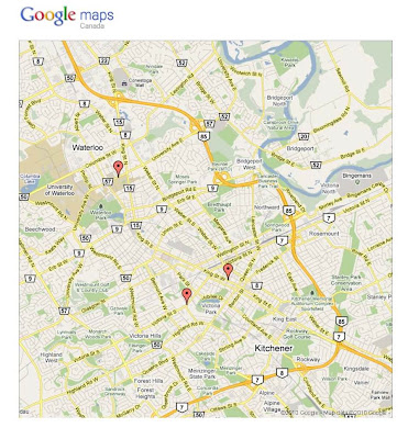
The geospatial web application we have chosen to examine is bike routes on Google maps. A bike route is a section in the Google maps application that allows users to locate a bike route or path. This is an important aspect of the application because in towns with universities especially, students use bikes as a major method of transportation. This allows users to ensure there is a safe bike route that can take them to their destination and tell them how long it should take from the starting point to their destination. This is not only important for students as more and more people everyday are using bikes as a method of short distance transportation because it is the greener option of travel. As an example of this application, below is a photo showing popular bike routes right here in Waterloo.

Ashley Kennedy
Alexander Troop
Drew Melnyk
Gabriella Gomes
Matthew Salsbury  

Family Watchdog


The Family Watchdog application is used as a means to view registered sex offenders all over the United States. There are multiple ways to search for offenders one being by name and the other by neighbourhood. The neighbourhood view is displayed on Yahoo Maps. According to US law all sex offenders residing in any state must be registered with that particular state. Family Watchdog is a website that allows anyone with internet access to view locations and information of every registered sex offender. This application is important because it helps members of society to be aware of the dangers in and around their neighbourhoods. The objective of Family Watchdog is simply put on their ‘about us’ link, “Our goal at Family Watchdog is to provide you with the information you need to protect your loved ones.” (familywatchdog.us). This website exists because of The Sexual Offender Act of 1994 and Meghan’s Law. The Sexual Offender Act of 1994 requires sex offenders to register with a national and state database while Meghan’s Law requires that this information be available to the public. Due to Meghan’s Law, applications similar to Family Watchdog are able to exist for the purpose of informing the American public on the issue of sex offenders.  

Nicole Berube
Meghan McIntosh
Robert Quinlan
Jackie Smith

Poynt


Poynt is an easy to use all-in-one geospatial application for the Blackberry smart-phone, Iphone,  Ipod touch and Android. The free application utilizes GPS and WiFi (or 3G network) capabilities to give accurate and relevant connections to the outside world. This highly advanced technological application connects the user to businesses, retailers, and services while providing various amounts of information regarding movie information and guides, restaurant locations and reviews, gas stations in close proximity and best prices available and is even able to track and locate friends, colleagues or relatives. Images of Poynt are shown in Appendix A. Overall Poynt’s easy accessibility to the geospatial network gives the user a variety of options to make everyday activities much easier.

Sarah Williams
Jasmine Folger-Laronde
Jordan Drexler
Michael Finn
Dustin Dubiel

Map Quest’s Bar Locator

http://www.mapquest.com/


When it comes to geospatial applications, MapQuest is definitely one containing a great amount of information. Www.mapquest.com is a website/ geospatial application that allows you to view the world. The purpose of MapQuest is to help people, wherever they are, locate places, generate directions, and know the approximate time it will take to travel between destinations.. For the purpose of our assignment, we have decided to go into greater detail on the bar locating application that MapQuest offers to its users. The top menu bar of the map contains a scroll bar with many different search applications that make it possible to find hotspots easily. To locate and apply the bar finding application, you scroll through the list until you find the martini glass icon, then click on it. After clicking the icon numerous numbered bubbles pop-up on the current map you are viewing. The bars have been tagged so that if you place your mouse over the bubbles, the address of the chosen bar will appear in what resembles a speech bubble. Along with the bubbles appearing on the map, a legend is generated on the left side that allows you to see all the tagged bars. From the legend you can generate a route and directions to and from bars.

Dave Drago
Cory Hudson
Allyson Oliphant
Catherine Reining
Taylor Wright

Glympse


Glympse, a geospatial application developed to share your location with friends, family and business associates . Glympse is an application which uses smart phone technology to track real time locations and make them available for others to view. With Glympse, security features permit you to choose who is able to see your current location. These features allow for you to post your location to the social networking sites Facebook and Twitter or merely send it to the phone of a selected individual. The technology of real time location sharing provided by Glympse is an important tool in communicating with others and an alternative to texting or talking while driving . Because the program displays a real time location of your whereabouts it is easier for people to locate you and know of your safety. Glympse is an application that can be used for numerous purposes with the main objective to share your geographical location, routes and destinations. Location sharing applications are not only available with Glympse but through different programs such as Loopt, Gowalla and Foursquare. The program Loopt allows you to use your current location to find friends, places and activities nearby . Gowalla is another program which is designed to share your location with others as well as share your experiences through photos and recommendations . This application also provides ‘badges’ for explored locations like Foursquare. Foursquare is the application which simulates a game, encouraging people to explore new spaces for point collection . Although Glympse does not provide features such as nearby attractions, location recommendations and photos or a game like experience, it is an ideal program for simple location communication. Before getting into more details about Glympse, here is a video describing this geospatial application:

http://www.youtube.com/watch?v=wg-MsCQJ6n4

Mathew Cart
Alexa Lupinacci
Phil Reid
Graeme Singleton
Nicole Smith

Cycling the Alps


The geospatial web application www.cyclingthealps.com is a Google Earth and Google Maps based website, used to familiarize cyclists with various possible cycling routes. This is beneficial for cyclist enthusiasts, as it allows them to navigate the Italian alps from the comfort of their home. Not only is the website a convenient source of detailed information regarding cycling routes in the Alps, but it also allows one to personalize their adventure based on skill level, intensity of the route and scenery. The website offers tourists from around the world the chance to experience multiple trails suited to their needs, just by the click of a button. By using GIS data collected and distributed by Google, this website demonstrates that it is no longer necessary to spend money on maps and travel guides, as users can simply plan their own trips (Roxanne Nelson, 1999). Not only does the user have access to the experiences of previous cyclists, but they can view their chosen route in 3D, as if they are already there. This geospatial application is the first of its kind, covering every aspect required for planning an unforgettable trip. Applications like these will soon be cropping up everywhere, for uses from hiking trails, canoe routes and skiing paths, to cross country road trips. Because of Google, online mapping has exploded into a phenomenon that gives ‘being there’ a whole new meaning (National Geographic, 2010).

Lauren Boutilier
Jennifer Hickman
Colin Donoghue
Shinead Macfarlane
Kayla Cressman

Twitter as a Geospatial Tool


Twitter  is a social media tool use for expressing a user’s message in a form of micro-blogging called tweets. Tweets can be seen publically and be forwarded which is known as re-tweeting, it can also be linked to various applications and social networking sites like Facebook  and Pikchur . This ability enables an acceleration of the spread of information concerning environmental and geographic issues. Many smart-phones are Twitter compatible, with this ability; users can transmit crucial data to a global audience within minutes of an environmental disaster or updates of ongoing issues. Although the current user base in approximately 175 million many mainstream media outlets such as Al Jazeera , CBC  etc. use Twitter collect and spread information to an even wider audiences.  An example of how Twitter can spread information about geographic and environmental issue is the Haitian Earthquake in 2010. British Red Cross  aid workers on the ground were able to provide information to relief workers enroute via Twitter. This information was used to coordinate relief efforts. While Twitter is limited to a 140-computer character message Twitter also provides the ability to instantly tag photographs with GPS coordinates. In the case of the Hungarian Aluminum  smelter slag spilling into the Danube this function allowed for instant damage assessment.  The ability to transmit both text and images from any internet connection including smart-phones makes twitter an important tool in the arsenal of geographers and environmentalist. For these reasons, it is likely that the importance of Twitter will increase to the fields of geography and environmentalism.

Terry Eckmeier
Sean Pollock
Annemarie Petejan
Sarah Penner
Courtney Jones

EveryTrail


 http://www.everytrail.com/

The application that we decided to review is EveryTrail. EveryTrail is a geospatial application that provides a way to share trips, connect with other travelers and find great new things to do.
The following can be done on this application:
            Map a trip route with your phone or GPS
            Add trip photos to your map instantly
            Add maps & photos to your blog or website
            Explore and share in the EveryTrail community
EveryTrail provides multi-dimensional benefits. These benefits include mobile travel guides that are paperless and location- aware. These guides are written by experts and are constantly updated with new points of interest. In addition, EveryTrail also provides guides on using different EveryTrail applications such as “EveryTrail Audio Guide”. Furthermore there is a blog where members can share their maps, routes and photos.
 EveryTrail applications are available for iPhone and Android phones for free. Some features are not available on the free application and require you to purchase the full application for a fee of $3.99.
Lastly, what would an application be if it was not able to social network? EveryTrail allows you to post a map on your website or blog, share on Twitter, Facebook and other social networking sites, e-mail your trip, and share in the EveryTrail community.

Erin Bradley
Rabia Chaudhari
Tracy Swierenga
Justin Wall
Brandon Wilkinson

EveryTrail


EveryTrail is a GPS based web and phone application that is used to create tours, road trips, day trips, and even small sight-seeing pathways.  Users can upload their own GPS files to the website, add pictures and commentary, and make their own personal route available for others to use, enjoy and improve.  Not only can this application be used to create trips for other members of the community, but it can be used as an extremely effective way of sharing your adventure with other people (sort of like a Facebook application dedicated to travel).  For example, say you’ve planned a trip to see New York City, but you’ve never been before and you’d like to take in some of the local culture, see the sights, and enjoy a little exercise.  Using EveryTrail you may search something such as “Brooklyn Bridge,” and a guide will appear in the search pertaining to what you want to see.

The thumbnail view of the guide gives you an idea of difficulty, the time involved in taking the route, the distance traveled, and a short synopsis.  Click on the thumbnail and it will bring you to the guide.  This guide includes step-by-step instructions from a firsthand viewpoint, a synopsis of the trip, some basic tips, photos of the area being toured, and an audio guide.  The application also provides you with a weather forecast in the side bar.  As for the map, there is an interactive map built off of a base map from Google that shows all of the various steps or stops on the trip and reveals the locations where the photographs were taken.  The route is easy to see on this map at it is drawn in red, and the sites are labeled clearly with numbers, and there is a key at the side to show which number corresponds to which site:

Overall, this application provides a user friendly, web based source of firsthand data from all over the world for people looking for adventure or people who want to share their adventures with their peers.

Michael Winters
Trevor Heyd
Sarah Pitzen
Natalie Garbutt
Mark Bullard

TravelPod


www.travelpod.com

TravelPod (www.travelpod.com) is a geospatial web application that allows users to post blogs, images and videos of travelling experiences on the web. The application then takes location information and places marks on a global map so viewers can see where the travelling experiences took place. It is an important and relevant geospatial web application as viewers can gain understanding and experience of different locations around the globe by simply viewing other peoples’ blogs. An additional purpose to this is that viewers can plan their own travels based on experiences posted by other travellers. People can find the trip and the activities to do during their trip that are perfect for them. We discovered a Travel Blog posted on Travelpod outlining a trip to Cairo, Egypt that we found extremely helpful and interesting in a number of different ways. The blog included a map (provided by Google Maps) with a placemark on Cairo, Egypt so we could see exactly where these travel adventures were taking place. The blog also included images of pyramids that the traveller saw when they were there, which we found very interesting. Along with the map and images, the blogger posted recommendations of places to see in Cairo such as Al-Azhar mosque. The blogger also included information about travelling to the mosque – such as women having to wear long dresses and something to cover their hair. The blogger then recommended Egyptian pizza and recommended that travellers avoid the use of trains within Egypt as they are not very clean. From one blog, the viewer has information on what to eat, what to see and what to stay away from when travelling to Cairo as well as understanding exactly what to expect there!

Aryana Heit
Allison Rohacek
Brett Walker
Tyler Curtis
Jordan Temple

San Francisco Solar Map

http://sf.solarmap.org/


The city of San Francisco has created a geospatial application where they have mapped all known locations within the city where solar panels have been installed. This application pinpoints all types of areas that are using solar panels to power, or help power the building. The vast majority shown on the map are residential buildings. This application is important because it shows the growth in renewable resources. The San Francisco Solar Map’s goal is to advertise the success and importance of solar power. On the map there are special bubbles to click on which take you to a case study depending on the bubble. Each one tells a story of a home, business, or office, and their experience with solar energy. These case studies advertise local businesses and links to their websites who install the panels. With each installation in the city, the coordinates are uploaded to the website and placed on the map with a marker depending on their zone. This map is a great way to spread awareness and information on the renewable energy source of solar power. This application holds many links to other resources on solar power, expanding the knowledge of a user. This geospatial application promotes and advertises the use of solar energy within the city, and around the world. Other application projects for San Francisco Solar Map include the uploading of additional information on previous installations, and the acquiring of solar potential of a certain area on the map. If you are a previous owner of solar panels and have added more to your building, or upgraded, you can add more information to the map by accessing your previous account to share with the community. Also if you do not yet have solar panels and are inquiring, you can input your address and the map will show a picture of your building along with a rooftop's solar PV potential, along with estimates on prices, and how to get started in fitting your home with solar panels. “What a great selling tool for people interested in purchasing PV, but are unsure whether they have the right roof for solar.” (Underwood, 2008)

Katrina Sunter
Eric Dance
Brian McMullen
Mark Elbertsen
Stephan Pidruczny

MAPme


The application that we chose to use for our blog is called MAPme.  Proclaimed to be a less frustrating version of the well known Google Maps, MAPme allows users to create maps based on any theme that they desire, in any location around the world. Users may choose any theme for their map, from the locations of their favorite restaurants in downtown Toronto to the best campsites locations in the province of Alberta or even a map that displays city transport routes in Waterloo.  By using place marks to show locations, users are able to map pretty much anything they want. Not only can this application be used to create maps, but has a community function that allows users to search maps based on a certain topic of interest. Any user who joins a specific community is given the ability to further update the maps within that community, such as adding locations, descriptions or place marks. Other applications that could have been used such as Google Maps and Map Quest were considered, but we ultimately chose MAPme because it creates a personal map that applies directly to the author. Furthermore, it allows others to view any map created on this site, and even add new locations or ideas to the map when applicable.  In our project, we have created maps that are of interest to the student population at Laurier. One map will display restaurant locations, another will show popular “night life” locations and finally one will display all the Universities located in Ontario.

Brandon Taylor
Emery Oram
Kal Watts
Katerina Linger
Nicole Pette

Trapster


Trapster is a geospatial web application produced by Microsoft for smart phones. It can be used to identify possible risks or to alert you of situations you may encounter while driving. The objective of this application is to make the road a safer place to drive. It attempts to accomplish this by allowing drivers to access geospatial data that has been provided by other users of the application. When a user comes within range of a risk or alert tagged by another user, the corresponding icon on the screen flashes and a pre-recorded voice warns the driver of the upcoming situation. Given the name, Trapster was originally designed to alert drivers of live police traps, fixed speed cameras and known enforcement points. However, since its creation it has been further developed to include safety information such as icy or flooded roads, accidents, children playing in the streets, dangerous intersections or curves, and school or construction zones. By providing this information drivers can avoid unsafe or slow-moving areas. This reduces their chances of being caught in traffic or speeding to make for lost time. Other applications like this are; Speed traps Lite, speed cam hunter, speed traps live, and oracle spatial.
 
Amanda Bielaski
Heather Haight
Josh Martella
Ashley Keenan
David Clark

WalkJogRun


 http://www.walkjogrun.net/

WalkJogRun.net (WJR) is a free and easy way to create and share exercise routes online. It is a tool that provides users with the ability to find statistics about their personal distance travelled, pace, and calories burned while doing activities such as walking, jogging, running or cycling. WJR will also provide the elevation changes of the terrain on any particular route. This elevation template gives insight as to the difficulty of a specific route or trail. The rationale for this particular application is to develop an online community of individuals who share similar exercise interests.
The WJR application is also available to use on your smartphone. The website offers an iPhone application to enable users to consult and update their accounts. Training plans are available for individuals of many levels and expertise. Beginners can specify they want a 5km run burning 450 calories, or experts can choose a marathon route. Where there are many web and iPhone applications that allow users to track time and distance of a run, WJR allows users to see routes created and used by others. This is useful for finding a new and exciting route around home or stimulating trails while on vacation.
Additional application projects available on WJR include the creation of groups, the ability to save routes, and an interactive weblog. Groups can be created to share routes and trails with others such as the Chicago Endurance Sports Running Group. This group posts city routes of varying length and difficulty for people to try and work up to.
There is also a weblog where people can find running events and share outdoor experiences. WJR allows you to connect with Facebook and Twitter accounts, buy merchandise, and register events you’re involved in online for publicity. It is an online route mapping site with unlimited potential!

Jaclyn Anderson
Emily Harason
Emily Haughton
Tom Rose
Deb Russell

YellowPages


http://www.yellowpages.ca/

For our web application case study, we have chosen the YellowPages application for mobile devices.   The application works much like the actual YellowPages and allows you to search by name, business, or phone number in a certain geographical area.  The purpose of the YellowPages application is to connect the user with businesses and to gain information instantly and electronically.  When you search the place of interest, it allows you to gain the information much like 411 on a typical phone.  Another feature that is available on the mobile device is Global Positioning System (GPS) which uses a series of satellites to pinpoint locations on the surface of the earth which then relays information to the receiver.  The YellowPages application then gives you options that are close to your position, giving detailed information about the business, video feeds of commercials, photos and advertising.  Using GPS location you can also search the type of business you are looking for and apply it to your location.  Thus, making it easy to choose your preferred destination based on distance and any other factors one may find important.  The application can also be sent to other users to tell them your location and where to meet and about the meeting place.  This application is extremely important because it links the user with any business within any area allowing them to plan whatever they want and get information about various businesses.  It is useful to the business as well because they are able to advertise and get their name out into the public.

Kate Parry
Derek Davies
Alex Coates
Elizabeth Murphy
Monika Buncic

GPS Visualizer


GPS Visualizer is a mapping editor and creator which was first released in 2002 and is available for use, without charge, at www.gpsvisualizer.com.  The initial reason for its creation was to create simple maps from plain text GPS coordinates that came off of hand held PDA’s and GPS units (http://www.gpsvisualizer.com/about.html, 2003).  Since that time, GPS Visualizer has evolved into a more in-depth program which allows for the creation and editing of maps.   One of the most significant innovations the application has achieved is its integration with Google Earth. This provides the user with an informative and visually appealing ‘base map’ which GPS Visualizer then overlays the input data onto, creating a polished map without any work on the user’s behalf.

The main aim of GPS Visualizer is to providing the user an accurate, polished representation of raw geospatial data the user uploads. According to the mission statement the application allows the consumer to “see where they've been, plan where they're going, or visualize geographic data (business locations, scientific observations, events, customers, real estate, geotagged photos, "GPS drawing," etc.)” (http://www.gpsvisualizer.com/about.html, 2003). An example of the practical use for GPS Visualizer would in a delivery service company which could display their data from the GPS units in their vehicles to monitor efficiency

Scott Stevens
Marc Sirizzotti
Jesse Armstrong
Anthony Todd 
Alexander Bertrand

Trailpeak

http://www.trailpeak.com/

Trailpeak Trail Data Base is a geospatial web application that is dedicated to mapping the distribution and location of various trails throughout North America including water, earth and snow trails. It is updated and maintained by the public allowing people from different areas, with different backgrounds, and varied skill levels to create a database with over 10,000 trails. Using the website is free but in order to become a member of Trailpeak Data Base, one must pay an enrolment fee of 25$. Once you pay this fee, you can update trails to your GPS and smart phones as well as post pictures, videos, and comments about your favourite trails. This fee also helps to keep the content legitimate keeping the trails and content at a high quality. There are several methods of finding trails including choice of activity whether it be hiking or canoeing, specific location, or skill level. Once you choose your map, a detailed map of the trail shows up usually accompanied by photos, videos, comments, and ratings. A section of the website is named “top 20 trails of the month” which permits users to navigate to the top ranked trails quickly and easily. The application is well connected to various social networks such as twitter and facebook allowing users to post trails on their different accounts. Although this site has many competitors such as Map Quest and Google maps, it has become quite popular since its establishment in 2001taking a unique spin on the geo spatial distribution of trails.

 
Chelsey Hyde
Daniel Murphy
Daniel Wilk
Kaleena Renault
Stephen O'Neill

Where's Willy?

 http://www.whereswilly.com/
The geospatial web application that we have chosen to critique is the Where’s Willy? website that utilizes Google Maps. Where’s Willy? website is a method for people worldwide to track Canadian currency in the forms of $5, $10, $20, $50 and $100 bills. Users are able to track their bills on the website to determine where the bills have travelled and how long it took them to get to each place. It is a useful application because it is connecting where money comes from and also indirectly, the people that obtain and record the money. The website is easily accessible and easy to maneuver around. People can input the necessary data about the bills such as, the serial number, their postal code, and an optional description of the condition or where it was obtained with ease. The application already knows the locations of the bills from an inputted postal code. It draws upon multiple databases that can be accessed through the original site. These databases are MySQL, PHP, and the largest one being GreatData.com.

The objectives of the geospatial web application are to monitor the values of currency that are being distributed and to observe the circulation and trends of the bills.  You can track the distance the bills have travelled, whether it is from a point A to a point B or the cumulative distance it has travelled. You can also calculate the average speed the bills were travelling at.  To conclude, Where’s Willy? is a website that monitors Canadian currency worldwide. All forms of bills can be tracked in a user-friendly manner within the website.

Ross Littlejohn
Michael Moser
Meaghan McDowell
Laura Staley

Picasa Web Albums


Picasa Web Albums is an online photo sharing service. With this web application, your photo collections can be uploaded to your own private web album. From there your photos can be shared with your friends, family or the rest of the world. The Google created product allows photos, albums, videos, and slideshows to be shared on the web and can be tagged geographically to enhance the viewing experience. We noted in this report that, commercial establishments such as tourist locations can benefit from Picasa Web Albums, as well as the possibility to share news stories on a global level.  Picasa is a perfect example of a fun and effective geospatial web application, as it combines data (photos, videos) on a geographic database (Google maps, Google Earth) on the web, making it easy for individuals to use.
There are many online photo-sharing sites, but two take the lead when it comes to mapping out photos - Flickr and Picasa.  The advantage of Picasa Web Albums over other photo sharing sites such as Flickr, is the option to manually specify the latitude and longitude (in decimal degree format).  Where Flickr on the other hand, only allows you to specify a location on a map by selection; which could lead to a large discrepancy of the actual location. With any of your photos or albums, Picasa can lay out the photographs on a map for a geospatial experience. Photos of road trips will be able to tell a story, show the route on the map and you will never have to remember, ‘where in the world was this photo taken’!

Tripgeo

http://www.tripgeo.com/

In an ever changing world, it is important to be able to understand the relationship between a space geographically and the experience it can bring. The application of things such as Tripgeo allow for one to plan an excursion with the luxury of knowing what kind of things to expect along the way.  Tripgeo is a geospatial application of Google Streetview that allows the user to design a walking or biking route while allowing the user to explore a desired route without any effort or travel being involved. The importance of such an application is that it allows the user to be able to plan to see different areas of interest such as tourist locations without having to leave the comfort of home. Tripgeo also allows the user to feel comfortable that the route they plan will include all that they want to see, and actually be able to preview the route before going out and exploring.   

Tripgeo has several user submitted examples of different routes, but gives the user the ability to create their own route and upload it to the website. The simple interface allows for a slideshow of the route to be played so the experience of the trip can be seen easier. One example map includes a tour of the Golden Gate Bridge and surrounding area. The only limitation to this application is that it is limited to places where Google Streetview is available, though more and more places are being added constantly to overcome this. 


Jong Lee (Kelly)
Kathleen Psenak
John Rizzo
Christian Scagnetti
Liv Uhrig

Trapster


 http://www.trapster.com/

When you are driving, wouldn’t it be nice to know where the speed traps are?  Well now is your chance with the new Trapster application.  This new application allows you to see where speed trap and red light locations are on the roads.  Each user is rated on their reliability and their information is sometimes negated from being used if the information was not backed up by other users. 
The application will even show you if a trap is expired by making the icon transparent.  Every piece of information that is gathered is retrieved by users and sent in.  Trapster does not have a team that locates speed zones, so this application is only as good as its users.  Since no one likes getting a ticket, this application has great incentive for people who use it.  Trapster also has other services such as road kill locators. However, for people to use these, they need that extra incentive. The legitimacy is questionable about the application because knowing where the speed traps are seems legally deceptive. The incentive idea is great to get people to use the other applications, but may fall short.


Nathalie Arkell
Nickolas Bryan
Kaitlin Friesen
Jason Grant
Risha Pandya
 

Sunday, November 28, 2010

SitorSquat


The SitorSquat geospatial web application allows you to “find and record bathrooms anywhere in the world”[i]. It provides a global database of public bathrooms to people all over the world through Google Maps. Sponsored by Charmin[ii], it is a site that allows you to upload photos, rate the bathroom, list your favourite bathrooms and comment on whether or not it is sit-or-squat worthy. This application can be viewed on your computer, iPhone, iPod Touch, Blackberry, or through SMS Texting. This application has been visited by over one million people worldwide, 60% of them being female and 40% being male.[iii] By typing in your GPS coordinates or simply the town/city you are in, place marks will appear allowing you to review and choose which bathroom is most suitable for you. The SitorSquat application is perfect for people travelling to unfamiliar places, long road trips, people with health issues, parents travelling with infants or small children and people who are simply very picky with where they go to the bathroom.  The founders of this application are Danika Landers, Jonathan Glanz and Andrew Halley-Wright.  SitorSquat started as a personal blog in October of 2007 and ever since then it has become an application talked about all over the news.  This application was mentioned on the Today Show, The View, The Wall Street Journal, Fox Business, the New York times and the list continues. The SitorSquat application was also recommended in Wired Magazine’s “Inside the GPS Revolution: 10 Applications That Make the Most of Location.”[iv] You can follow SitorSquat on Twitter, MySpace, Facebook or through the SitorSquat News Channel. 

Allison McManus
Olivia Rollo
Lauren Towne
Santana Moores
Matt McFater

[i] http://www.sitorsquat.com/sitorsquat/home/index
[ii] http://adage.com/digital/article?article_id=135482
[iii] http://www.sitorsquat.com/sitorsquat/static/media_kit.pdf
[iv] http://www.wired.com/gadgets/wireless/magazine/17-02/lp_10coolapps?currentPage=10


MapMyRide


http://www.mapmyride.com/

MapMyRide is a geospatial application that allows users to map and share recreational transportation routes. ‘Geospatial’ describes the software-based analysis of spatial and geographical data; in this case MapMyRide makes use of Google Earth software (WPSU, 2010). The website focuses on cycling routes, but the user can choose to map, among others, walking and running routes. Favorite routes with personal comments and geotags can be shared online: geotags such as ‘scenic’ or ‘off-road’ allow others to search for ideal routes to try out instead of their own. One can explore local areas, search for and rate maps and add comments. Users can plan events, facilitating user interaction outside the Internet. The events can be created to promote routes or causes, or to reach out to potential riders. Through this application, one can join a cycling or exercise club of sorts, connecting online to create a community of cyclists from home.

The application can be downloaded to Smartphones, tracking the user on their route and creating a map that can be uploaded to their profile. Outside of mapping routes, the user can plan workouts and create training programs. The application calculates calories burned, distance travelled, dollars saved on gas, and carbon offset. Once a member is a user, they can add friends and rivals to compare routes and foster some friendly competition. MapMyRide thus combines aspects of both geospatial technology and social networking.

 
Margot Couse
Dylan Harp
Brett Harrington
Bradley Kalman
Rebecca Mills


Saturday, November 27, 2010

Selected Geospatial Applications


Here are the 32 geospatial applications that students in GG251 Cartography have chosen to review:

Group 1: SitorSquat                       
Group 2:  MapMyRide                       
Group 3:   TripGeo                         
Group 4:  Picasa Web Albums      
Group 6 :  Trailpeak
Group 7:  Trapster     
Group 8: GPS Visualizer
Group 9:  Yellow Pages 
Group 10:  Walk Jog Run
Group 11  Trapster
Group 12:  Mapme
Group 14:  TravelPod
Group 15:  Everytrail
Group 16:  Everytrail
Group 17:  Twitter
Group 18:  Cycling the Alps
Group 19:  Glympse
Group 21:  Poynt
Group 22:  Family Watchdog
Group 23: Bike Routes on Google Maps
Group 24:  Facebook Places  
Group 25:  California Road Kill Observation System       
Group 26:  Cabspotting
 Group 28:  Gowalla
 Group 29: Foursquare
 Group 30:  Mapmyrun
 Group 31:  Mapmytri
 Group 32:  TripWiser

Saturday, September 18, 2010

Video Tutorials

Short videos are an excellent way to learn a software technique.  It might be useful to create a space on the blog to organize and access such video tutorials.
Here is a good site for Google Earth video tutorials.

Here's another kind of video that shows a map being created using heads-up digitizing from an image. 

Friday, September 10, 2010

Navigating Map Rap

Map Rap is laid out pretty much like a conventional blog.

Under the blog title are the Introduction to Map Rap, a library of Bookmarks to geospatial websites, a list of key websites in Canada, and some Readings.

The middle panel has two kinds of content (so far):

- periodic notes on the development of the geospatial web, as well as the blog itself.

- links to resources, including:  geospatial tools, and articles related to various issues and applications

 The left panel has two columns providing links to other blogs that relate to maps and the geospatial web.  Each blog is continuously updated, which makes this my favourite component of Map Rap.

On the right panel are Exhibits that present the geospatial web in different ways.  Under Geolinks are direct links to useful websites related to the geospatial. Labels are helpful when searching the blog for topics like tools, issues and applications.

Monday, September 6, 2010

Map Rap Blog Flog

Ready or not, its time to open this blog to the world, or at least to my students and my social network.  Given that I don't know how all the various blog functions work I may need a few pointers along the way, so feel free to comment and suggest.

I'm not sure how to involve others in its future development.  One way is for readers to add comments.  A second is for readers to send me stuff which I could then post.  A third is to invite others to join me as coauthors of the blog.  I'll figure it out as I go along.

On with the geospatial revolution!

Bob


Friday, August 27, 2010

"Ten Suggestions for Those Who Write About Local GIS Implementations"

This article by Adena Schutzber of Directions Magazine provides suggestions to consider when writing up a geospatial application.

Thursday, August 19, 2010

Top Blogs in GIS, GeoWeb and Cartography


In September, 2008 the blog 'Off the Map', posts a great discussion, especially in the numerous reader responses, that debates the challenges and issues in classifying online materials related to cartography, geospatial technologies, and the geoweb. 


Off the Map Presents Top 25 Blogs in GIS, GeoWeb and Cartography

Loss of Map Reading and Navigation Skills?

Mounting concern has been expressed that geotechnologies such as satellite navigation systems (GPS) and online mapping (MapQuest) are contributing to the loss of map reading and navigation skills.

Global Impositioning Systems:  Is GPS technology actually harming our sense of direction?
by Alex Hutchinson.  From the November 2009 issue of The Walrus


Finding and retreiving a topographic map

Here is a step-by-step guide to the searching for and retreiving a topographic map from the Canadian NTS map series.

Topographic Map Search

General Criteria for Evaluating a Cartographic Web Site

Accuracy
  • Who is responsible for the site?  Who is the author?
  • Is there contact information for the author?
  • Are the maps accurate?  If not, why not?
  • Is the site in good repair?  Are there any dead links?
  • Has it been updated recently? 
  • Authority
  • What kind of site is it?
  • Who is publishing or hosting the site?
  • What is the primary activity of the host?
  • What are the author’s credentials or qualifications? 
  • What is the source of the maps?
  • Objectivity
  • Why has the information been brought together for you find on the web?  What is the purpose of the site?
  • Is there any detectable bias in the site or its information?  Is there any reason to suspect a bias, e.g. the business of the publishing institution or the author?
  • Who decided what kinds of information is available on the site?
  • What were the selection criteria for the items included in the site?
  • Is the information freely available or is it available for purchase?  If you must purchase information, who is the money going to and why was it necessary to purchase the information?
  • Where did the maps come from?  Who originally produced them?  For what purpose?
  • Currency
  • When was the site published?  Has it been updated?
  • Is the site recent enough to be useful to your topic?
  • Are the maps current?  If not, when were they produced and does this date impact their relevance to your use?
  • Is the information available on the page still current or relevant?
  • Coverage
  • Is the information available on the site in the public domain or protected by copyright?
  • Were the maps or links carefully chosen?
  • Is the information organized in a way that makes it accessible and easily obtained?
  • What is the quality of the maps?
  • What kind of site is it? Is there a focus? Is there any bias in the selection of map information?
  • Does the site have a thematic, chronological, or geographic focus?
  • Deborah Carter Peoples Science Librarian Librarian Liaison to Geography and Environmental Studies Ohio Wesleyan University Libraries Geography 222 The Power of Maps and GIS is a faculty/librarian collaboration for course enhancement with principles of Information Literacy.  Support for this project was provided by the Five Colleges of Ohio Mellon Grant for Information Literacy.

    Wednesday, August 18, 2010

    Thursday, August 12, 2010

    Geospatial web - reading list

    I moved the reading list to a separate page under the blog title.

    I moved it on August 26, as I have begun to discover the limitations of using a blog for adding, searching and retrieving particluar types of information:  general messages, lists...

    Clearly the blog is effective for capturing the temporal release of information but maybe a website is better for???

    Wednesday, August 11, 2010

    Online Mapping

    I'm a little overwhelmed by the number and variety of online mapping applications.  In this post I will try to limit the selections to applications that allow users to create their own maps, rather than the more speciliased functions of trip planning, mapping and display, etc.

    Scribble maps

    Mapme.com

    OpenStreetMap

    Wikimapia

    Monday, August 9, 2010

    Map Tools

     Google Planimeter   measure areas using Google Maps
    Maptimize   clusters multiple markers that are in proximity

    Online Mapping Services

    Here's the start of a list of online mapping services.  I expect the list to grow, have URLs added, be sorted into different categories of functionality, and have brief annotations.  


      Sunday, August 8, 2010

      Geocoding addresses

      Here is how to quickly assign geographic coordinates to street addresses using the online program called, batchgeo

      First, prepare a set of  street addresses in a tab delimited format.  Here's an example I typed into a spreadsheet:

      Name Address City Province
      Cafe 175 West Ave Kitchener  Ontario
      WLU  75 University Ave. W   Waterloo  Ontario
      Kitchener  200 King St. W.  Kitchener  Ontario


      Second, cut and past this table into batchbgeo


      Third, follow the remaining steps laid out by the batchgeo software to set the options and geocode the table.  The map can be displayed online and/or saved as a kml file.  The kml file can then be loaded into Google Earth or imported into Google Maps, as shown by the map below.